
|
|
Glaciers, Penguins, and more: Patagonia at a glanceBy Tim YoungFrom SIF SATELLITE 56, Winter 1999/2000
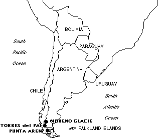
For those of us in the northern hemisphere, the thought of glaciers brings to mind Alaska, Canada, Iceland, Scandanavia, northern Russia. It may not occur to us that there are glaciers in South America. Mioko Ozaki and Akiko Kaneko, on their annual end-of-the-year international excursion (see Satellite 50-54 for the story of their travels to Israel and Austria), saw some of these glaciers when they visited Patagonia at the end of December. They saw the Moreno Glacier in Argentina and Grey Glacier in Chile. From listening to the story of their trip, I found that I knew much less about South America than I thought I did. Patagonia?Where, exactly, is Patagonia? Like the U.S. “Midwest”, the exact boundaries of the region are unclear. At the least, it is only the southern steppes of Argentina. At most, it includes the southern halves of Chile and Argentina—the area south of the Rio Colorado and Argentina’s Buenos Aires Province. Either way, it can be said to be a largely untamed area of the world, with few large cities. Although much of the land is divided by fences to keep in livestock, the tracts surrounded by fence could be miles wide. The origin of the name “Patagonia” appears to be a subject of some debate. Some say that Ferdinand Magellan’s crew, when they explored the area in 1520, used the word to describe the Tehuelche people who lived there at that time; “pata” means “paw” or “foot” in Spanish, and the Tehuelche wore extra-large moccasins. Another theory says that it comes from Patagon, a dog-headed monster from the 16th-century Spanish romance “Amadis of Gaul”; supposedly, the appearance of the Tehuelche reminded Magellan’s navigator of that fictional beast.
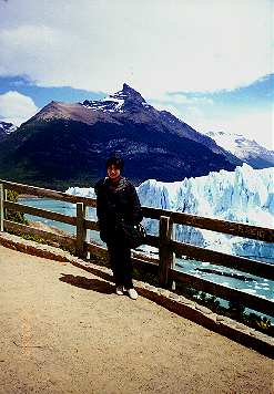
Gazing at GlaciersThe glaciers both lie along the Chile-Argentina border, not surprising when you realize that the border is the Andes Mountains. Both are in national parks. It was Moreno that our travlers visited first, on a clear day in what for South America was early summer. As the photos show, the glaciers and mountains of Patagonia are breathtaking. It’s no wonder they extended their stay there from two days to four. “This glacier was really beautiful,” Mioko recalls. “This is about fifty meters high, and you can see some people,” she says, pointing to tiny figures standing in front of the glacier in one of her photos. “They’re so small, you can see how big it is.” According to the Lonely Planet South America guide, “over millennia, Andean snowfields have recrystallised into ice and flowed eastward towards Lago Argentino and Lago Viedma, which in turn feed the Rio Santa Cruz, southern Patagonia’s largest river.” It adds that the Moreno Glacier, “the centrepiece of this conjunction of ice, rock and water”, is “one of the earth’s few advancing glaciers.” “When a glacier is heated by the sun in the afternoon, often pieces break off,” says Mioko. “And when it breaks off many sightseers will applaud!” Just to the south, and across the border into Chile, is Parque Nacional Torres del Paine, home of the Grey Glacier. “Torres” means “towers” and refers to the tall granite pillars in the park. Torres del Paine, a UNESCO Biosphere Reserve, is a 180,000-hectare park with trails and huts for hikers. “Last year there was a huge breakdown of this Grey Glacier, and now we can see ice on this lake,” Mioko says. As the photo on page two shows, what was once solid glacier is now simply some large pieces of ice on the water. Global warming? “In this Paine National Park, there are many guanacos (see page four) and many lakes. I’ve heard that glaciers, when they melt, the water is green like this.” Why? And why did the Moreno Glacier have a blue tinge to it? I asked a contact on the Internet about this; the response was: “Green water is caused by ‘rock flour,’ which is little bits of rock ground up by the slow motion of the heavy glacier across the ground. Blue tinge is because a glacier is essentially a huge set of crystals, which scatter light. Blue light is scattered more than any other color, so it appears blue when light hits it from above. Magellan and his Penguins
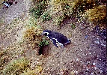
“The next day they traveled from Puerto Natales to Punta Arenas, on the Strait of Magellan. Despite its being summer, Mioko says, “It was very cold in this region, Patagonia, always the wind is blowing.” Perhaps this isn’t too surprising, considering its latitude (both Puerto Natales and Punta Arenas are between 50 and 55 degrees south latitude; cities at similar points of north latitude include Hamburg, Germany, and Edmonton, Canada) and the proximity of the ocean. Until the Panama Canal was built, about 100 years ago, the Strait of Magellan was an important stop on shipping routes. A 19th-century wool boom and the California Gold Rush helped entrepreneurs like Jose Menendez build business empires in this region. While we’re always told what a great idea the Panama Canal was, cutting days off the shipping time between Atlantic and Pacific ports (especially North American ones), it’s easy for us to forget that this wasn’t regarded as such a great idea at the tip of South America! Still, Lonely Planet says that the “Magallanes” area is still Chile’s most prosperous, due to wool, commerce, petroleum, and fishieries, as well as tourist attractions like Torres del Paine. Another claim to fame for this region is simply that Ferdinand Magellan was here; he “discovered” (from a European perspective, anyway) the strait which bears his name, and the islands of the area (the largest being Tierra del Fuego, “Land of Fire”, now split between Chile and Argentina). A statue of Magellan stands in Punta Arenas, which also boasts a Magellan Street. Yet another attraction is the magellan penguin. About three hours from Punta Arenas by bus is a grassy land that Mioko and Akiko visited to see these small penguins, who live in holes in the ground and grow to be about 80 cm tall. These are the only birds in the world which migrate by swimming! They migrate to such places as Tierra del Fuego (an island just across the Strait) and the Falkland Islands in order to breed. “They are very cute,” says Mioko. In that same area they saw an ostrich-like bird called the nandou. “On the way back to Punta Arenas, we saw a nandou walking with her children, but it didn’t pose for us!” she laughs. Before Mioko and Akiko told me about their trip, I had heard of Patagonia but didn’t know what area it referred to. Now I’m hoping to visit there someday. |
Copyright 2004 This page last updated
October 8, 2004
. E-mail Tim
This page last updated
October 8, 2004
. E-mail Tim
 The
Tehuelche, by the way, fared no better than most natives of the Americas
did in the face of colonization by Europeans: along with the Alacaluf
and others, most of them were massacred in Argentina’s “Conquest
of the Desert” campaign in the 1870s.
The
Tehuelche, by the way, fared no better than most natives of the Americas
did in the face of colonization by Europeans: along with the Alacaluf
and others, most of them were massacred in Argentina’s “Conquest
of the Desert” campaign in the 1870s.